"See, the Lord has one who is powerful and strong. Like a hailstorm and a destructive wind, like a driving rain and a flooding downpour, he will throw it forcefully to the ground."
-Isaiah 28:2

Friday, July 20, 2012

The Chase Is On


Well, now that the low pressure system has finally begun to fire storms over the Puget Sound, they will be moving North/ North East by this afternoon. Our chase day so far has started off with lighting outside our window and torrential rains that just do not seem to want to go away. As I stated yesterday, the storms of the Central Cascades region will begin to develop from 18z to 19z, so that gives us our time to pack and prepare the vehicle. Because supercells become more likely from 4 to 7pm, we shall be leaving our current location around 3pm.
{SPC Friday Tornado Outlook}
                This morning the SPC had released their severe weather outlook, giving our targeted area a 2% chance of seeing a tornado (and that is as good as it gets throughout the entire nation) within fifteen miles of any given point. This is due to sufficient shear standing at thirty to fifty knots and large CAPE of 1000+ J/km.
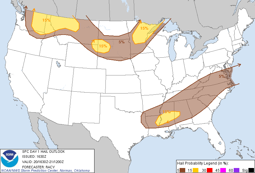
{SPC FridaySevere Hail Outlook}


{SPC Friday Severe Wind Outlook}


At this moment the SPC has issued their current mesoscale discusion...


MESOSCALE DISCUSSION 1513
   NWS STORM PREDICTION CENTER NORMAN OK
   1132 AM CDT FRI JUL 20 2012 
   AREAS AFFECTED...PARTS OF NE OREGON/ERN WASHINGTON AND ADJACENT
   IDAHO 
   CONCERNING...SEVERE POTENTIAL...WATCH POSSIBLE 
   VALID 201632Z - 201800Z

   PROBABILITY OF WATCH ISSUANCE...60 PERCENT  

   SUMMARY...TRENDS ARE BEING MONITORED FOR AN INCREASING SEVERE THREAT
   THAT COULD REQUIRE A WATCH BY EARLY AFTERNOON.  

   DISCUSSION...MID-LEVEL FLOW STILL APPEARS GENERALLY SUBSIDENT ALONG THE EASTERN FRINGE OF A 50-60 KT SOUTHERLY 500 MB JET STREAK LIFTING THROUGH EASTERN OREGON AND WASHINGTON.  BUT CLEAR TO PARTLY CLOUDY CONDITIONS ARE ALLOWING FOR CONSIDERABLE INSOLATION...AND DESTABILIZATION OF A MOIST BOUNDARY LAYER ACROSS THE WALLOWA/BLUE MOUNTAINS VICINITY NORTHWARD THROUGH MUCH OF THE COLUMBIA BASIN. LATEST OBJECTIVE ANALYSES AND MODEL FORECASTS SUGGEST THAT CAPE IS IN THE PROCESS OF BECOMING MODERATELY LARGE...ON THE ORDER OF 1000 TO 2000 J/KG...AND THIS IS EXPECTED TO BECOME SUPPORTIVE OF VIGOROUS CONVECTIVE DEVELOPMENT AS MID-LEVEL FORCING FOR ASCENT INCREASES AHEAD OF AN UPPER TROUGH BEGINNING TO LIFT NORTHEAST OF THE CASCADES.  GUIDANCE INDICATES STORM DEVELOPMENT MAY INITIATE AS EARLY AS 18-19Z...BEFORE INCREASING IN COVERAGE/INTENSITY DURING THE AFTERNOON.  VERTICAL SHEAR WILL BE MORE THAN SUFFICIENT FOR SUPERCELLS WITH AT LEAST A RISK FOR LARGE HAIL AND LOCALLY DAMAGING WIND GUSTS.  LOW-LEVEL HODOGRAPHS ARE MORE UNCERTAIN...BUT AN ISOLATED TORNADO MAY NOT BE OUT OF THE QUESTION...PARTICULARLY EAST OF THE SURFACE LOW...NEAR/NORTH OF THE YAKIMA VALLEY.


Thursday, July 19, 2012

Severe Weather to Hit the Northern Rockies Again


                SPC has now given North Central Washington, The Idaho Panhandle, and North Western Montana a slight chance of severe weather this Friday. While there seems to be no imminent threat for tornadoes in the highlighted areas, there is a 15% chance of a severe storms developing within the given area.  Looking at the forecast models, the hardest hit areas will involve the northern and central Cascade Mountains with a widespread chance of a quarter to half an inch of rain within a three hour period. Strong humidity will spread across the region with winds varying from nine to twenty three knots. Dew points are expected to stay mild with hot temperatures. With a mix of low sheer and a strong CAPE, the chance for tornadoes will be low, though strong winds, heavy rains, frequent and dangerous lightning, and hail to reside. Storm are expected to fire fairly early (11am PDT to 3pm PDT) and develop further from there.  Because the low pressure system that is moving its way north will be aided by cold air, the most common cells that are predicted to form will be multicell’s and supercells- though large hail will be the primary threat.


At the moment our team is planning to head up to the northern portion of the highlighted area for a possible deployment, as we have been on the road and collecting our data since the 7th of July. Though we have not seen a tornado yet, we have taken data from a wall cloud. Our most productive days have so far fallen on the 10th, 14th, 15th, and hopefully the 20th.

                On the 10,th while we were able to do our deployment we did face quite the serious threat- lighting. Though we were already well aware of the strong threat for the electrical discharge, we did expect it to be as frequent as it was- especially when it struck 500 yards to the south west of where we were deploying.  We collected data on several other storms in both the Bitterroot and Big Hole Valley of South Western Montana. Add an eerie orange and purple glow to the skies due to the many wildfires in the area and we had ourselves on heck of a chase day.

Thursday, July 5, 2012

The Road


               As a research team we do travel quite a bit so that we may find the perfect storm for deployment. Though I, myself have been quite the road trip prodigy my entire life (at one year old my parents drove me from Portland to Seattle in three hours), not everyone else has. It is here that I shall share my knowledge of life on the road. What kind of road trip will we be talking about? Well, we’re going to be talking about the one taking place in less than 24 hours.

                Over the past five years, the ROTATE team has managed to drive from our headquarters in Seattle, Washington and to our chasing domain in Montana in a matter of twelve hours or less. We first begin by checking the forecast models when we enter within ten days of the trip. Afterwards we take inventory of what we have and what we need to order on-line, do several test deployments, and by the time we need to pack everything up we have all that we need- including the training- and load everything in the back of our vehicle . We end the week by going to bed at 7pm.

                That Saturday morning (as usual) we wake up at 4am, shower, do hair, make-up, etc., and proceed to walk out the door. From there we drive for four hours before stopping for breakfast in central Washington. By 8:45 we are back on the road, driving five more hours into Coure D’ Alene, Idaho by 1pm. We usually stop at a Carl Jr.’s or a Sonic before continuing our trek through the Idaho panhandle and into western Montana. As part of tradition we stop in St. Regis, Montana for a snack and maybe a little bit of splurging at the tourist store at the gas station. Dinner usually falls around 4pm at a pizza place in Missoula before we head south to our temporary base. All in all, we arrive around 7pm MDT, unpack, set up equipment and go to bed by 9pm.

                Now, on a more personal level, while taking my five hour shift at the wheel, we have the radio going constantly. I myself prefer to drive for long periods of time to Bon Jovi, Journey and Def Leppard. My brother prefers that apocalyptical music of Likin Park and some other weird bands that refuse to record quality, good mood music. Also, I usually go for a coffee whenever the chance is offered. Driving for five hours through plains can be very tiring. However, past noon I shoot for water so as not to dehydrate myself along the way.

                We, like most chase teams out there, have several good luck charms also. I have a necklace that I was wearing when I saw my first tornado back in’09. My brother has a plaque like thing with a tornado and lightning inscribed on it along with the ROTATE logo on it. As a conclusion, and mostly out of exhaustion and dread of the coming days, I leave you with this post. I will not be checking back until my return on Thursday, July 12th. Until then, I bid you adieu and many blessings.


Monday, July 2, 2012

Bipolar Forecast Models


               I apologize for the confusion that I am relaying. Now that the forecast models are beginning to look better than before, and have entered the “some-what reliable” time frame, the ROTATE team is beginning to throw around the idea of where our target areas are going to be. At the moment we are considering the northern portion of the Big Hole Valley and Butte, Montana. So far it does appear that we are actually going to get a full 24 hours to set up and have everything prepared on Sunday. Considering the models, we are looking into the deployment in the Butte area on Monday and the Big Hole Valley deployment on the following day, though even at this point we cannot be completely sure. The weather changes faster than a teenagers relationship status- let’s just end it at that.

                On Thursday we will be display a more fun post featuring life on the road; Until then, goodbye everyone. (:

Sunday, July 1, 2012

Forecast Update

                    Despite the fact that the forecast models hinted at severe weather for three consecutive days, this morning they dropped out and began forecasting solid sun and heat for our chase domain. Now, I will once again state that though the time frame for the forecast is relatively smaller and more susceptible to accuracy, we are still looking at conditions eight days out. From my thirteen years of studying meteorology I can tell you that they will most likely change by the time they are guaranteed accuracy-for better or for worse. As of now we are still looking at good amount of lift and instability, but it seems that our CAPE has flown the coop along with any source of moisture. To better communicate the desperation here, I will not-so-happily say that this next week is our first and last chance to deploy and collect data on a tornado this entire year. Our next chance comes again next summer in the southern portions of Montana and the Black Hills of South Dakota. Believe me when I say that this forecast worries me…